
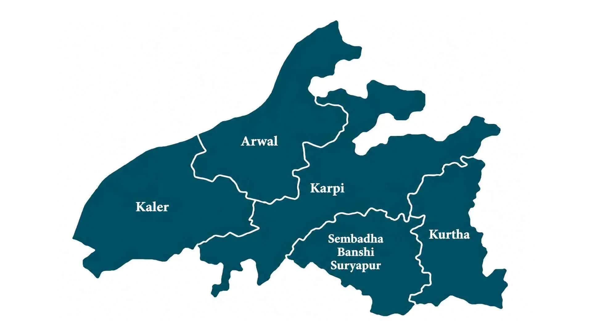
Arwal
Arwal is a small district in southern Bihar, carved out of Jehanabad district in 2001. Its economy is primarily agricultural, with the Sone River forming an important geographical feature.
- Headquarters
- Arwal
- Division
- Magadh Division
- Established
- 2001
- Area
- 638 sq km
- Population
- 700,843 (2011)
- Lok Sabha
- Jehanabad
- Vidhan Sabha
- Arwal | Kurtha
Arwal District, Bihar
Overview
Arwal is a district in southern Bihar and forms part of Magadh Division. Arwal town is the district headquarters. Established in August 2001 after being separated from Jehanabad district, Arwal is among the smaller districts of Bihar by geographical area.
The district is known for its agricultural landscape, rural settlements and location along the Sone River region.
History and Heritage
Arwal was historically part of the larger Jehanabad administrative region. For many years, it functioned as part of Jehanabad district before becoming a separate administrative district in August 2001.
The creation of Arwal district was intended to improve administrative accessibility and facilitate the delivery of government services to its population.
Its historical and cultural identity is closely connected with the wider Magadh region, which has played an important role in the history of Bihar.
Geography and Administration
Arwal covers approximately 638 square kilometres and is part of Magadh Division. The Sone River forms an important geographical feature along the western side of the district, while the Punpun River system also influences the local landscape.
The district has one subdivision and five administrative blocks: Arwal, Kaler, Karpi, Kurtha and Sonbhadra Banshi Suryapur.
Its geographical position connects it with neighbouring districts including Jehanabad, Patna, Bhojpur, Rohtas, Aurangabad and Gaya.
Population and Demographics
According to the Census of India 2011, Arwal district had a population of 700,843. The district is predominantly rural, with agriculture and associated activities supporting a substantial proportion of its residents.
Hindi and Magahi are among the commonly used languages. The district's population is distributed across villages and a relatively small urban settlement around Arwal headquarters.
Economy and Agriculture
Agriculture is the principal economic activity in Arwal. Paddy, wheat and maize are important crops cultivated in the district.
The Sone river system and irrigation infrastructure contribute to agricultural activity. Rural markets, small businesses, livestock rearing and local trade also support the district's economy.
Improving irrigation facilities, agricultural productivity, rural infrastructure and employment opportunities remains important for economic development.
Political Significance
Arwal forms part of Bihar's Magadh political region. The district is represented in Parliament through the Jehanabad Lok Sabha constituency.
It has two Bihar Legislative Assembly constituencies: Arwal and Kurtha.
These constituencies provide political representation for the district's population in the Bihar Legislative Assembly and contribute to the wider political landscape of southern Bihar.
Culture and Tourism
Arwal shares the cultural traditions of the historic Magadh region. Local religious festivals, village fairs, traditional celebrations and community activities form an important part of its cultural life.
Its rural settlements and river surroundings reflect the traditional landscape of southern Bihar. Cultural connections with neighbouring Jehanabad and Gaya districts also contribute to its regional identity.
Education and Healthcare
Arwal has government schools, secondary educational institutions and colleges serving its urban and rural communities.
Public healthcare services are delivered through government hospitals, primary health centres and community health facilities. Improving access to specialised medical care and higher education remains an important development requirement.
Transport and Connectivity
Arwal is connected by road to Patna, Jehanabad, Aurangabad and other neighbouring districts. Its location along the Sone River makes regional road connectivity important for commerce and daily travel.
The district relies significantly on road transportation for passenger movement, agricultural trade and access to major railway and airport facilities in neighbouring urban centres.
Development and Urban Growth
Agricultural modernisation, irrigation, rural roads, education, healthcare and employment generation are among Arwal's important development priorities.
As a relatively small district, strengthening local administrative facilities and improving access to public services are central to its continued development.
Arwal District Today
Arwal remains an important administrative district of Magadh Division. Its agricultural economy, Sone River geography and connections with neighbouring districts contribute to its regional significance. The district continues to focus on improving rural infrastructure, public services and economic opportunities.